|
|
|
|
 |
|
SPOT 1
|
|
|
|
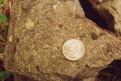 This is definitely a sedimentary rock. It is a pebbly conglomerate with good quartz and feldspar grains that touch. The darker maroon grains are rhyolite pebbles. This is the lower Mount Rogers Formation and is similar to what we saw at the first stop - only not quite so coarse. This represents our mountain streams with gravel bars. This is definitely a sedimentary rock. It is a pebbly conglomerate with good quartz and feldspar grains that touch. The darker maroon grains are rhyolite pebbles. This is the lower Mount Rogers Formation and is similar to what we saw at the first stop - only not quite so coarse. This represents our mountain streams with gravel bars. |
|
|
|
|
|
|
BACK TO QUESTIONS
BACK TO VIRGINIA CREEPER TRAIL MAP
|
|
SPOT 2
|
|
|
|
| The rusty brown color, the heavier heft, and the fine grain size indicate that this is a basalt, an igneous rock!!! The rounded forms are pillow lava!!! This is a characteristic form that happens when lava erupts underwater. The view of the pillows is that you are looking at the bottom of the lava beds. If you come around to the side of the outcrop and view it from edge you will notice that the main layering here is nearly vertical and that it is slightly overturned (rotated past 90 degrees). It is difficult to know what body of water the basalt erupted into. It is unlikely that it was an ocean body, however, as most of the lower Mount Rogers is indicative of land stream conditions. |
|
|
|
|
|
|
BACK TO QUESTIONS
BACK TO VIRGINIA CREEPER TRAIL MAP
|
|
SPOTS 3 & 4
|
|
|
|
 Douglas Rankin in his 1967 guidebook maps these rocks as rhyolites, making them igneous. What makes this difficult to tell is that the rocks have become quite slaty, thus obscuring most of the primary igneous structures. Overall, the rock is quite fine grained. If you were to see this rock in the field you would note how shiny the rock is along the flat surfaces. This is from mica growth as a result of metamorphism. If you compare the rocks from spot 3 to 4 note that the planar texture becomes more pronounced. The slaty texture is a result of shearing along a fault (the Catface Fault) and we are getting closer to the fault. One note for those interested in igneous petrology: the fact that we see both basalt and rhyolite (mafic and felsic - two ends of the igneous compositional spectrum) and no andesite (intermediate between the two ends of the spectrum) tells us that the tectonic setting is a rift and that we had two separate magma sources - one from the lower continental crust (the rhyolite), and a deeper mantle originated source (the basalt). Andesites are commonly found associated with collisional plate boundaries and are associated with magmas generated at subduction zones - not the situation we have here. Douglas Rankin in his 1967 guidebook maps these rocks as rhyolites, making them igneous. What makes this difficult to tell is that the rocks have become quite slaty, thus obscuring most of the primary igneous structures. Overall, the rock is quite fine grained. If you were to see this rock in the field you would note how shiny the rock is along the flat surfaces. This is from mica growth as a result of metamorphism. If you compare the rocks from spot 3 to 4 note that the planar texture becomes more pronounced. The slaty texture is a result of shearing along a fault (the Catface Fault) and we are getting closer to the fault. One note for those interested in igneous petrology: the fact that we see both basalt and rhyolite (mafic and felsic - two ends of the igneous compositional spectrum) and no andesite (intermediate between the two ends of the spectrum) tells us that the tectonic setting is a rift and that we had two separate magma sources - one from the lower continental crust (the rhyolite), and a deeper mantle originated source (the basalt). Andesites are commonly found associated with collisional plate boundaries and are associated with magmas generated at subduction zones - not the situation we have here. |
|
|
|
|
|
|
BACK TO QUESTIONS
BACK TO VIRGINIA CREEPER TRAIL MAP
|
|
SPOT 5
|
|
|
|
| The reason why the rocks changed is that we have crossed the Catface Fault and have crossed into the Konnarock Formation. Note that the rocks contain numerous fractures healed by milky white quartz veins indicating the deformation associated with the fault. |
|
|
|
|
|
|
BACK TO QUESTIONS
BACK TO VIRGINIA CREEPER TRAIL MAP
|
|
SPOTS 6 & 7
|
|
|
|
|
No, the cobbles don't generally touch.
|
|
|
|
|
|
|
|
|
BACK TO QUESTIONS
BACK TO VIRGINIA CREEPER TRAIL MAP
|
|
 |
|
 |
 |
 |
|
 |
|
|
|
|
|
|
|
|
|
|
|
|
|
|
|
|
|
|